I-55 runs north-south, just west of mid state. The area we covered – Grenada to Como – sits west of the Hill Country and east of the Delta, and surely vies only with the Gulf Coast in the number and scope of outdoor activities available. We visited Grenada Lake, Enid Lake, and Sardis Lake before we ran out of time – we’ll see Arkabutla Lake on another trip – and we found them all absolutely beautiful. These lakes and their surrounding recreational areas are true Mississippi treasures.
The three lake areas we visited look similar in many ways, which isn’t that surprising since they are all U.S. Army Corps of Engineers flood control projects. They’re so well done – well laid out, clean, and meticulously maintained, with sandy beaches and conveniently located boat landings. All three lakes are so big that each meets the horizon – scan any of them (at least from shore, as we did) and it’s like looking out to sea. That came as a real shocker to us for some reason. Like most Mississippians, we’re used to seeing both sides of a waterway at once. And we visited the first of April, when water levels are somewhat lower, providing more shoreline! (During the fall and winter months the lakes are drawn down to allow for storage of spring rains.)
 |
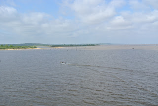
| Beautiful Grenada Lake. Looking west off of the bridge on Scenic Loop 333 |
We started our tour about three miles northeast of the town of Grenada, at Grenada Lake, a reservoir on the Yalobusha and Skuna Rivers. The entire Corps project covers 90,427 acres, with the lake itself covering an incredible 36,000 acres – making it the biggest in Mississippi. It boasts 148 miles of shoreline, seventeen boat landings, and eight public beaches. There’s a fine Visitor Center (2151 Scenic Loop 333), with an overlook that provides a panoramic view of the lake. The center offers a theater, historical and cultural exhibits, and information on recreational facilities and area attractions.
 | |
| Fishing area and picnic area off Scenic Loop 333 |
There’s no lack of activities. Visitors can boat, fish, jet ski, swim, picnic, golf, play tennis or basketball, walk trails, hunt, bird watch – the list goes on and on. The nearby Hugh White State Park has cabin rentals – some with screened porches and fireplaces – and a lodge that accommodates thirty-five people. History buffs will want to check out a couple of Civil War redoubts; reenactments are occasionally held here.
Grenada Lake is a delight any time of year, but it’s especially fun in June, when Grenada Lake Association holds its annual “Thunder on Water.” Voted one of the Top 20 tourism events in the Southeast, it’s a safe-boating festival that includes a fishing rodeo, carnival rides, a tractor pull, concerts, wrestling, bike and car shows, arts and crafts and more.
Enid Lake
Moving north from Grenada, we came to Enid Lake on the Yocona River. The smallest of the three we visited, Enid is about twelve miles south of Batesville, and on the map it’s dwarfed by Grenada Lake. Consequently, we were gobsmacked to see that it’s huge! The permanent pool is a sizable 6,100 acres, with a flood control pool of some 28,000 acres. The enormity of these projects is almost overwhelming.
 |
| Taken from atop the dam at Enid Lake |
The lake is known for its family camping facilities and its accessible fishing pier below Enid Dam. There are ten launching ramps around the lake, making it easy to boat, fish, and enjoy water sports. And thirteen recreation areas (most equipped with launching facilities) offer camping, hunting, swimming, picnic areas, and trails of every kind – bike, equestrian, off road vehicles, and all sorts of hiking and nature trails. Between Enid Lake and George Payne Cossar State Park next door, visitors will find plenty to do.
And for the record, Enid Lake garnered a world record when someone caught a five-pound crappie! Crappie is pronounced “CROP py” by the way, and while we don’t have a clue why it’s spelled that way, we think there might be a good story there.
Sardis Lake
Sardis Dam, on the Little Tallahatchie River, is nine miles southeast of the town of Sardis. The dam is 15,300 feet long, with an average height of 97 feet.
Sardis Lake is a huge body of water - 9,800 acres, with a control pool of 58,500 acres. Known for its sandy beaches, it's as beautiful as the other two, and a favorite of anglers. These Corps projects are just outstanding.
To say the fishing is great at Sardis is an understatement. Al Reed, who hails from Independence, Mississippi, broke the world record (32 pounds) for Big Head Carp when he landed a 65-pounder at Sardis Lake – huge news in the fishing world. Not surprisingly, it took Al forty-five minutes to land this fish, which was almost four feet long!
Not in the mood to fish? There are eighteen public recreation areas, thirteen with launching facilities. Nearby John Kyle State Park offers a swimming pool, recreation hall, rental cabins and a golf course. And, if you're checking out the facilities, be sure to go by the Sardis Lake Field Office. They have a lighted stop sign that's solar powered - a contraption worthy of a drive by!
http://www.recreation.gov/recAreaDetails.do?contractCode=NRSO&recAreaId=154&agencyCode=130
 |
| Well...guess the name says it all. This store is located on the road to Sardis Lake |
 |
| And...this lighted sign was in the front of the Dam Store. |


No comments:
Post a Comment